Desolation Wilderness- Crystal Range
- AlexMitchko
- May 7, 2023
- 4 min read
Updated: Sep 29, 2025
Desolation Wilderness, or Deso as the locals call it, is where my first backcountry experience in Tahoe took place. Arriving in Lake Tahoe in August of 2018 to finish my undergraduate degree, we had a choice of what type of orientation we’d like to participate in. I, along with most of my friends, opted for a wilderness orientation: a five day, four night backpacking trip along various trails in Desolation. This was my first non-winter camping experience and it was an amazing, formative experience. From sheer granite slopes to secluded high-alpine lakes, this dreamscape perfectly encapsulates the beauty that Lake Tahoe has to offer.
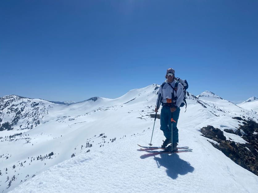
This spring Alison Hardy, a badass splitboarder and perennial Tahoe local, and myself ventured into Desolation for an overnighter to immerse ourselves into one of the best backcountry ski zones that Tahoe has to offer. On April 13th, I picked up Alison and we made our way towards the Inspiration Point trailhead. We double checked our gear, turned on our beacons and hit the trail. We climbed to the saddle created by Maggie’s South and North peak, contoured around the backside and began a short, skins-on descent en route to Dicks lake. This section can be tricky as it's very easy to get lured towards either Azure lake or Eagle lake if you drop off the northside of the ridge.
Alison making light work of the split ski out of camp, Camp setup with Dick's Peak in the background


We stopped just above Dick’s Lake and set up camp there with perfect views of Dick’s Peak and the Fontanillis ridgeline. Once our tents were up we began towards the highest point above Upper Fontanillis. Met with perfect velcro-like skinning conditions and warm temperatures, we couldn't be happier with the timing of our trip. After this short skin we were looking down a fun, east facing descent to the (frozen) lakes below. Perfect corn conditions once again reaffirmed this feeling that we had made the right choice on when to venture back here.
Looking down towards the Fontanillis family of lakes, Ridgeline pictures for mom

We transitioned at the lakes and set our eyes on Dick’s peak. This would not only give us an idea of what the ski quality was like off Dick’s but also a better vantage point to scope out prospective lines for tomorrow's adventure. Meandering our way towards the base of Dick’s, navigating the countless glide cracks and reapplying sunscreen incessantly was just what the doctor ordered. Ascending the NE facing bowl on Dicks proved to be a bigger challenge than we had anticipated. My ski crampons were not grabbing to save my life and with no boot crampons my only choice was to kick steps that penetrated about an inch or so. Luckily Alison was getting a good bite on her split crampons as climbing this slope in soft boots would be a death sentence. It was roughly 40 minutes of kicking steps and precariously working our way up to the summit.
Alison looking towards Dick's Peak, Pyramid and Mt. Price looking moody


Although the boot up was quite engaging , the views of the south Crystal Range were well worth the effort. We transitioned rather quickly as storm clouds were rolling in quite fast and we descended the bulletproof face we hiked up, and caught the only flat light our entire trip. We made it back to camp, made some water and ate some snacks as we deliberated on options for tomorrow. At camp, the clouds that engulfed us at the top of Dick’s surprisingly produced a few snowflakes for us. Nothing too substantial, but enough for me to get my rainfly attached to my tent.
The next morning we decided to head back towards Pyramid Peak & Mount Price. With conditions similar to our first day, we took our time getting out of camp and once again went up to the ridgeline that separates Dick’s Peak and our Fontanillis descent. We worked our way slightly south on the backside of Dick’s peak and began to descend towards Rubicon River. We had our sights set on skiing Little Pyramid (Mt. Ryan) as it looked like a perfect mix of a mellow approach and an engaging descent. We crossed the river easily and began to move through the trees towards Mt. Ryan. I vividly remember it being a scorchingly hot day, having to stop for water with hydration tablets often and cherishing any moments we could in the shade. The route finding was fairly simple: going up the path of least resistance heading SW until we reached the ridgeline. Barring a small tricky section just below the ridge, the ascent was fairly simple.
Checking the maps to measure twice, cut once , Alison making her way towards Rubicon Peak with Jack's Peak on the left


Now moving north on the ridge towards our summit, we transitioned to bootpacking and within 20 minutes we were on top. The views from Ryan were exceptional and we even ran into another skier which took us both by surprise. We had some snacks and talked about the beauty of this place before we began downhill. Another near-perfect corn snow ski all the way back down to the river!
Alison working her way up Little Pyramid, Our lines back down


Another transition and we were on our way back towards our first ridgeline of the day. Water breaks and sunscreen were once again the theme of our ascent back as it was truly an incubation chamber out there. A short ski back down to camp and we were on our way back to our car. Retracing our steps from day one went much faster than both Alison and I anticipated. A crunchy ski down off Maggie's South and we were back to our car in no time.
This was my first time skiing deep into Desolation Wilderness and it certainly won't be my last. Below attached are my Strava activities if you're looking to replicate this trip.


Comments